A lecture by Dr. Wen-Shing Chou (Hunter College, CUNY)
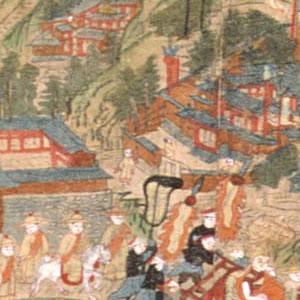
The northern Chinese mountain range of Mount Wutai has been a preeminent site of Buddhist pilgrimage for over a millennium. During the Qing Dynasty (1644–1912), Buddhist rulers and monks from Inner Asia, including Manchus, Tibetans, Mongols, and Monguors, developed the sacred site into an important center of Gelukpa Buddhism (the sect of the Dalai Lamas). This lecture considers the Inner Asian Gelukpa transformation of Mount Wutai through popular pilgrimage maps of the mountain during the later half of the Qing. Who created them, disseminated them, collected them, and why? Among the many maps of the mountain produced during this period, a panoramic wood-block image carved at Mount Wutai by a Mongol lama in 1846 had an exceptionally global and transcultural career. A plethora of images in different media were made from the 1846 carving. By tracing the life and afterlives of the woodblock map, I argue that the heterogeneous, collaborative, and accretive process of mapmaking mirrored that of Mount Wutai’s place-making. Each act of carving, printing, coloring, framing, copying, and circulating the map image delivers a new and different vision of the mountain, highlighting the role of maps and their makers and users in the transformation of a sacred site.
Wen-shing Chou is Asst. Professor of East Asian Art at Hunter College, City University of New York. She holds a BA in Art History from the University of Chicago (2001), and an MA and PhD in History of Art from University of California, Berkeley (2011). Chou has published numerous essays on the visual and material culture of Buddhist pilgrimage, and recently completed a monograph on the Inner Asian transformation of Mount Wutai in Qing China.